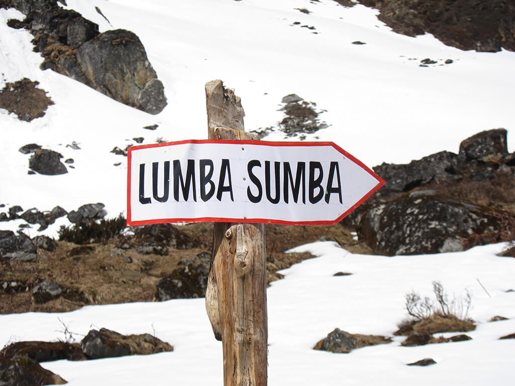

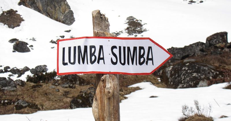
The Lumba Sumba Pass trek was only recently opened in 2012 by the trekking agencies assioaction of Nepal, so it is a relatively new trekking route . The trek connects the Kanchenjunga region and Makalu region via the Lumba Sumba Pass, and runs through the Kanchenjunga Conservation Area and the Makalu Barun National Park in the eastern part of nepal and can be done in one of two directions: starting in either Kanchenjunga or in Makalu.
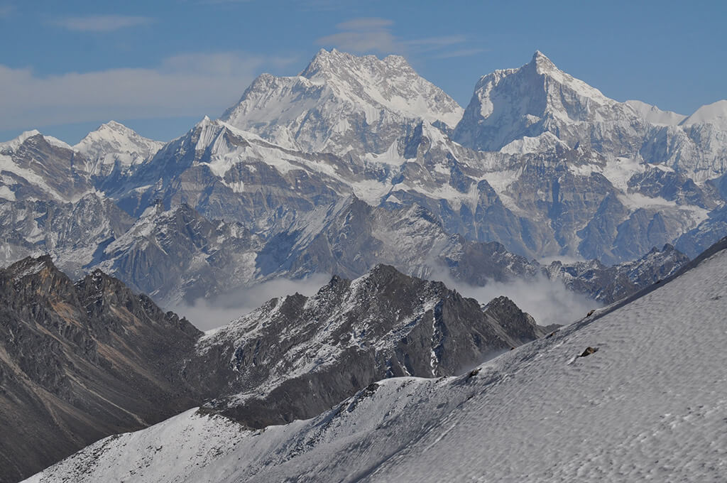
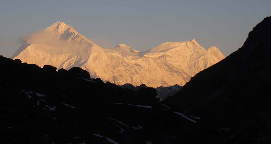
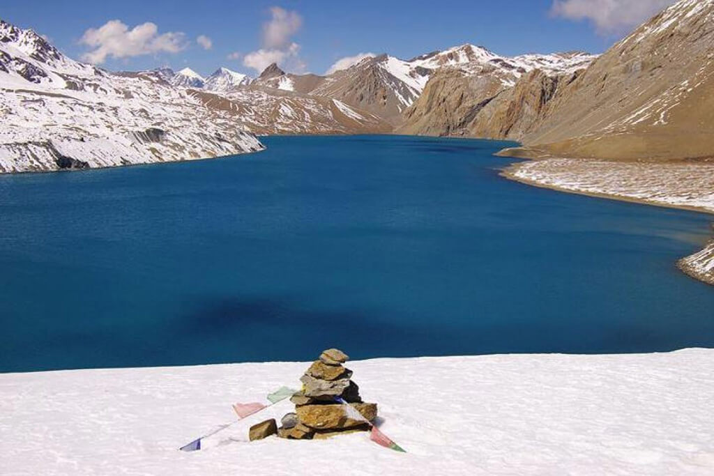
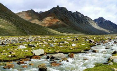
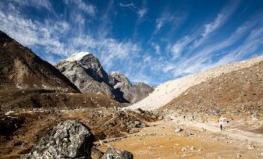
Highlights of this trek include the Lumba Sumba Peak (5,300m); spectacular Himalayan landscapes of the Makalu and Kanchenjunga ranges; different ethnic villages (Limbu, Sherpa, Rai, Gurung, Tamang); cultural heritage; endangered wild life such as the snow leopard and red panda; the base camps of Mount Kanchenjunga and Mount Makalu, and major river systems. This trek offers a variety of landscapes and natural beauty although this trek can sometimes be harsh in less than good condition, so its no surprise that this is a strenuous trek.It is recommended that trekkers on this trail have prior experience.
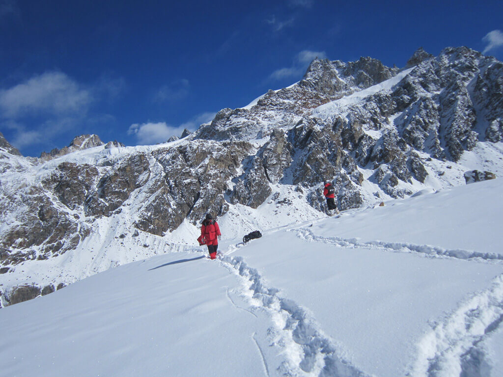
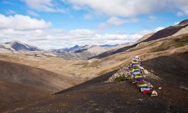
The trek passes through scattered pockets of human habitation in the form of villages, monasteries, markets and schools and there are days when trekkers are completely alone in the wilderness, particularly on the most difficult day – when they cross through the Lumba Sumba Pass.
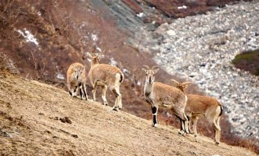
During these days off the beaten track there have been sightings of snow leopards, which would certainly add a new excitement to the journey! After crossing the pass, while hiking through the Arun Valley, there is opportunity for bird watchers to spot several unique and rare species. This is the ideal trek to enjoy spectacular mountain views and learn something about village life in eastern Nepal, throwing in a cultural mix of chortens, temples, monasteries and prayer wheels.
Day 1: Arrival in Kathmandu
Day 2: Sight seeing in Kathmandu,
Day 3: leaving Kathmandu,
Day 4: Trek from Fungling to Mithlung 909m/5 hours
Day 5: Trek from Mithlung to Chhirwa 1246m/6 hours
Day 6: Trek from Chhirwa to Lelep 1687m/7 hours
Day 7: Trek from Lelep to Ila Danda 2051m/5 hours
Day 8: Trek from Ila Danda to Selep Kharka 2525m/5 hours
Day 9: Trek from Selep Kharka to Olangchung Gola 3208m/5 hours
Day 10: Trek from Olangchung Gola to Upper Langmale 3893m/6 hours
Day 11: Trek from Upper Langmale to Pass Camp 4747m/6 hours
Day 12: Trek from Pass Camp to Chaurikharka 4595m/5 hours via Lumba Sumba Pass 5177m
Day 13: Trek from Chaurikharka to Thudam 3500m/7 hours
Day 14: Trek from Thudam to Yak Kharka 2877m/6 hours
Day 15: Trek from Yak Kharka to Chyamtang 2229m/6 hours
Day 16: Trek from Chyamtang to Hatiya 1595m/7 hours
Day 17: Trek from Hatiya to Gola 1128m/6 hours
Day 18: Trek from Gola to Hedangna Gadi 1179m/5 hours
Day 19: Short trek from Hadangna Gadi to Num and drive to Tumlingtar 405m by jeep
Day 20: Flight from Tumlingtar to Kathmandu from the domestic airport in Tumlingtar
Day 21: Free day in Kathmandu
Day 22: Departure
Outline
Day 1: Arrival in Kathmandu
Day 2: Sight seeing in Kathmandu,
Day 3: leaving Kathmandu,
Day 4: Trek from Fungling to Mithlung 909m/5 hours
Day 5: Trek from Mithlung to Chhirwa 1246m/6 hours
Day 6: Trek from Chhirwa to Lelep 1687m/7 hours
Day 7: Trek from Lelep to Ila Danda 2051m/5 hours
Day 8: Trek from Ila Danda to Selep Kharka 2525m/5 hours
Day 9: Trek from Selep Kharka to Olangchung Gola 3208m/5 hours
Day 10: Trek from Olangchung Gola to Upper Langmale 3893m/6 hours
Day 11: Trek from Upper Langmale to Pass Camp 4747m/6 hours
Day 12: Trek from Pass Camp to Chaurikharka 4595m/5 hours via Lumba Sumba Pass 5177m
Day 13: Trek from Chaurikharka to Thudam 3500m/7 hours
Day 14: Trek from Thudam to Yak Kharka 2877m/6 hours
Day 15: Trek from Yak Kharka to Chyamtang 2229m/6 hours
Day 16: Trek from Chyamtang to Hatiya 1595m/7 hours
Day 17: Trek from Hatiya to Gola 1128m/6 hours
Day 18: Trek from Gola to Hedangna Gadi 1179m/5 hours
Day 19: Short trek from Hadangna Gadi to Num and drive to Tumlingtar 405m by jeep
Day 20: Flight from Tumlingtar to Kathmandu from the domestic airport in Tumlingtar
Day 21: Free day in Kathmandu
Day 22: Departure
Detail Itinerary
Day 1: Arrival in Kathmandu , You will be met by a representative at the airport who will take you to the hotel en-route you will get a brief glimpse of the sights and sounds of Kathmandu. Once at the hotel you will be introduced to your trekking guide who will brief you about the trek.
Day 2: Sight seeing in Kathmandu, on this day you will be accompined by our local guide to various world heritage sites , like syambunath, pasupatinath , boudha and the durbar squares at patan and basantapur.
Day 3: leaving Kathmandu, on this day you will be leaving Kathmandu by flight for bhadrapur after you land in bhadrapur you will travel by jeep to taplejung. It’s a good 5-6 hrs drive but you will enjoy the scenery along the way as you leave urban areas and enter rural Nepal .
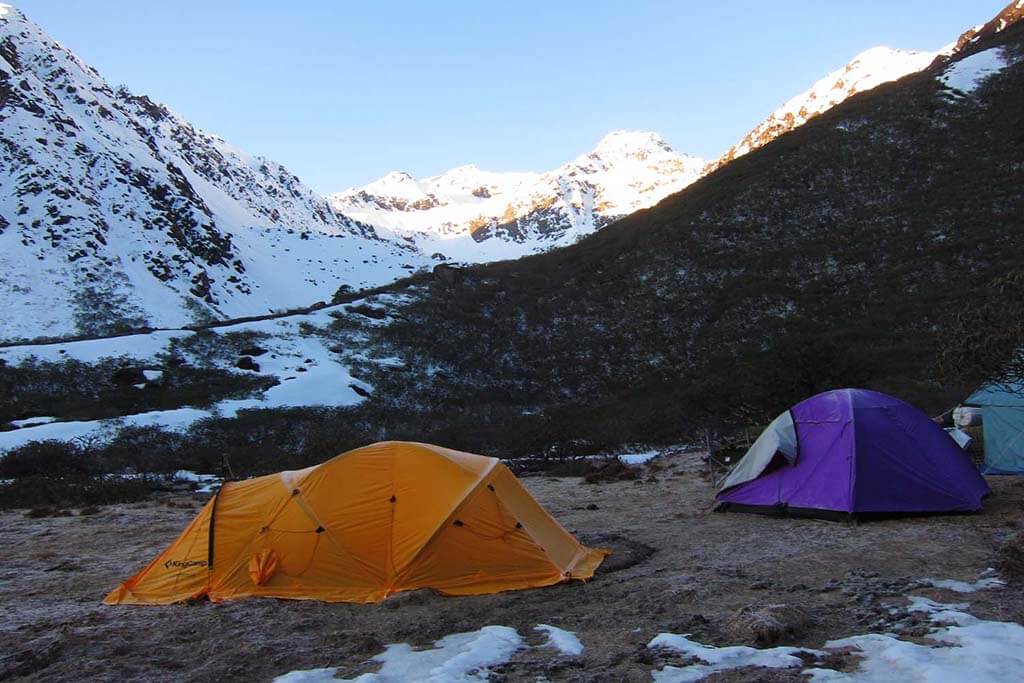
Day 4: Trek from Fungling to Mithlung 909m/5 hours this is the first day of your trek, It starts from fungling which is the official headquarters of the taplejung district. On the way, there are small tea sops at Asangpati Tole that can be used for alternative accommodation as they provide home stay facilities. From Panisar, the trek is downhill until the suspension bridge that acts as a border between Hangdewa VDC and Furumba VDC. A walk of 10 minutes takes us to Pawa Village (1546m) for lunch. After lunch, the trek progresses along the bank of Tamor River to Mitlung – a walk of around two hours. Mitlung is our destination for the day as it has good camping sites. Overnight at tented camp with full board meals.
Day 5: Trek from Mithlung to Chhirwa 1246m/6 hours
The trek passes along the banks of Tamor River on the second day. It is a pleasing walk until Furumba —a 40 minute walk from Mitlung. From Furumba, the trail is uphill for half hour then descends through Ulnus and Schima wallachiana mixed forest to Siwa Bazar (950m) at Linkhim VDC. We can reach Siwa Bazar is a good place for lunch. It is a small market with facilities like drug store, groceries and a police station. After Lunch, the trek runs along the Tamor River until Tawa Village. Tawa Village has a small tea shop. The trek runs uphill from here until we reach the KCAP entrance gate (1300m) at Thiwa Village. From here, the trek gradually descends until Chiruwa- our destination for the day. Chiruwa (1246m) is a small market with couple of lodges and good camping sites. It is a popular stopover for tourists and locals alike. Overnight at tented camp with full board meals.
Day 6: Trek from Chhirwa to Lelep 1687m/7 hours
This day also the trek runs along the mighty Tamor river. At the start of the trek, there are two big stones with religious significance. The trek passes through Ulnus trees passes until we reach a big landslide that takes around half an hour to cross. After a walk of two and half hours from Chiruwa through beautiful cardamom gardens, we reach Tapethok (1340m) for lunch. It is a small market with some tea shops. There is also a KCAP checkpoint at Tapethok. After lunch, it is a pleasing walk for about an hour until Pembu (1486m. From Pembu, it is an uphill climb for about two and half hours to Lelep (1687m) — our destination for the day. The KCAP headquarters is in Lelep. Similarly, there is a police station, some tea shops, groceries and hotels. Overnight at tented camp with full board meals.
Day 7: Trek from Lelep to Ila Danda 2051m/5 hours
After breakfast, the trek runs along the bank of Tamor River through dense forest that offers good habitat for different wildlife species. You can see some wild species if you lucky. We crossed a suspension bridge, it is an uphill climb through pine forest for about half an hour until we reach a monastery. From there, the trek gradually descends after about half an hour and we reach Gowatar (1800m) for lunch. Gowatar is a small settlement with a few houses. Near the village, there is a big stone and it is believed that only the religious people can move them. After a walk of around half hour from Gowatar, we reach a place that offers spectacular views of two waterfalls about 100 meters tall. A walk of about half an hour from here takes us to Phedi. After crossing Tamor, River, it is an uphill climb for about 40 minutes until we reach a resting place known as Chautaroo in local dialect. Another 20 minutes walk will take us to our camping site Ela Danda (2051m). The place offers panoramic view of snowcapped peaks including the small Kasturi peak and Tamor River. Overnight at tented camp with full board meals
Day 8: Trek from Ila Danda to Selep Kharka 2525m/5 hours
The walk on the fifth day is pleasing as it passes through Ulnus and Rhododendron forest for about an hour until we reach a suspension bridge. After crossing the suspension bridge, the trek passes through dense bamboo groves. The place is popular among trekkers as the habitat of red Panda. If you are lucky, we might catch a sight of red panda from the trail itself. After a total walk of three and half hours from El Danda, we reach Maguwa (2423m) for lunch; the trail passes through maple and Ulnus forest. There is a big landslide on the way and trekkers must be careful while crossing it. After a walk of about one and half hour, we reach Selep Kharka (2525m) — our destination for the day. Overnight at tented camp with full board meals.
Day 9: Trek from Selep Kharka to Olangchung Gola 3208m/5 hours
Today trek runs along the bank of Tamor River leading to a place called Jongim (2641m), a flat land surrounded by snow capped hills, after a walk of about an hour. Another 40 minutes walk through rhododendron forest from Jongim, takes us to a suspension bridge. After an uphill walk of about an hour, we reach Ramite (2685m) for lunch. At Ramite, we can see mixed forest of Deodar and rhododendron. We see a beautiful waterfall after a walk of about an hour from Ramite. If you are lucky, you might be rewarded with the views of red panda from here. We caught the first glimpse of Olangchung Gola after a walk of around 45 minutes from the waterfall, we finally reach the camping site at Olangchung Gola (3208m) Olangchung Gola is a beautiful Sherpa village with around 45 houses, a 465 years old monastery with golden manuscript and KCAP office. There is also a sub-health post, a primary school and a border police station at Olangchung Gola. Overnight at tented camp with full board meals.
Day 10: Trek from Olangchung Gola to Upper Langmale 3893m/6 hours
The trek in the next three days will pass through complete wilderness. However, piles of stones along the way act as signs posts, showing us our direction. The trek passes through pine and rhododendron forests. After a walk of two and half hours, we reach a place called Jadak (3636m) for lunch. A walk of three hours on snowy track will take us to our camping site at Upper Langmale (3893m). Overnight at tented camp with full board meals.
Day 11: Trek from Upper Langmale to Pass Camp 4747m/6 hours
The eight day trek can be interesting as snow leopard have been sighted numerous times from this trek. The trek runs along the Tamor River and on the other side of the river lies dense rhododendron forest. After a walk of about three hours, we reach Tangchetar (4203m) for lunch. Another three hours walk after lunch will lead us to our camping site at pass Camp (4747m). Overnight at tented camp with full board meals.
Day 12: Trek from Pass Camp to Chaurikharka 4595m/5 hours via Lumba Sumba Pass 5177m
This would be the most difficult yet most memorable day of this trek. This day trek will pass through the Lumba Sumba Pass (5177m). The trek climbs a bit up and again runs down. It is better to take packed lunch, as there are no good camping sites around. After a walk of about four and half hours from pass camp, we climb the Lumba Sumba Pass and descend down to Charikharka (4595m) for night’s stay. Overnight at tented camp with full board meals.
Day 13: Trek from Chaurikharka to Thudam 3500m/7 hours
The trek is downhill from Chaurikharka as we come back to civilization after tiring walk for three days. After a walk of about three and half hours, we came across two roads — one to Lyasha in Tibet and the other toward Thudam . We prepared our lunch at this place. A walk of about three hours takes us to Thudam for the night’s accommodation. Thudam (3500m) is a small village with around 30 houses of Sherpa people. Overnight at tented camp with full board meals.
Day 14: Trek from Thudam to Yak Kharka 2877m/6 hours
The eleventh day trek runs along the banks of Chujung Khola. The trail offers panoramic view of peaks in the Makalu range. On the way you see lo of small bushes and bamboo groves-the best habitat for red panda. If you are lucky, you can see this endangered species. It is better to carry packed lunch, as it is difficult to find drinking water along the trail. After a walk of about six hours from Thudam, we reach Kharka (2877m) for the night’s halt. Overnight at tented camp with full board meals.
Day 15: Trek from Yak Kharka to Chyamtang 2229m/6 hours
The twelfth day’s walk passes through dense rhododendron forest. As there are no village on the way and also there are numerous side trails. After a walk of about three hours from Kharka, we reach a place called Chaurikharka for lunch. From Chaurikhara, we can clearly see Chyamtang (2229m). Arun River, Ridha Village and the road that leads to Kimathanka. After lunch, the trek is all downhill for about three hours until we reach Arun River. After crossing the suspension bridge over the Arun, the trek is uphill for about an hour until Chyamthang — our destination for the day. Chyamthang (2229m) is a small houses. Sherpas are the dominant population in the villages. Overnight at tented camp with full board meals.
Day 16: Trek from Chyamtang to Hatiya 1595m/7 hours
The trail on the day passes through rhododendron forest. The walk is easy as chirping of birds make you feel refreshed. The trail is one of the popular places for birding as we are entering Arun Valley that is home to several bird species. A walk of about two and half hours from Chyamthang take us to Glimber Village (1585m) for lunch. Gimber Village offers spectacular view of snowcapped peaks in the Makalu range. From Gimber, the walk is easy and after a trek of about three hours we reach Hatiya (1595m) for the night’s stay. Hatiya- a small village of Bhote people — is the entry point to the Makalu National Park. Overnight at tented camp with full board meals.
Day 17: Trek from Hatiya to Gola 1128m/6 hours
The trek on the 14th day runs along the banks of Arun River. After a walk of about two and half hours from Hatiya, we reach the confluence of Arun and Barun rivers. After having lunch near the river confluence, the trek progress towards Gola – our destination for the day. A walk of around two and half hours after lunch takes us to our camping site at Gola. Gola is a very small village with 12 houses. Sherpa, Rai and Tamang people reside here. Overnight at tented camp with full board meals.
Day 18: Trek from Gola to Hedangna Gadi 1179m/5 hours
The trek passes through paddy fields on the 15th day – a sign that we are at lowlands now. The walk is pleasing as the trail makes a short descent, but again makes a short climb. After a walk of about two and half hours from Gola, we reach Pathibhara (not to be confused with the Pathibhara temple in Taplejung district) for lunch. Pathibhara (1524m) is a small Gurung village with tea shops, groceries and some hotels. The trail after lunch passes through agricultural land and we can find plenty of water sources and small settlements along the way. We reach Gadhi (1800m) -our destination for the day- after a walk of around three hours from Pathibhara. Gadhi is a place of great historical significance as Nepali Army fought bravely with invading Tibetan Army at this place and chased them away. Gadi is a small village market with a health post, a school and a police station. Overnight at tented camp with full board meals.
Day 19: Short trek from Hadangna Gadi to Num and drive to Tumlingtar 405m by jeep
This is the last day of our trek. A walk of about tow and half hours from Gadi takes us to Num. From Gadi, the trek is about an hour downhill till the Arun River. After crossing the river, an uphill climb of about one and half hour takes us to the Num village (1572m). As Num is linked with motorable road, we can take a drive to a drive of around 4-5 hrs on dirt road takes us to Tumlingtar. Overnight at Guest house with full board meals.
Day 20: Flight from Tumlingtar to Kathmandu from the domestic airport in Tumlingtar
After breakfast, we straight to the airport and fly for Kathmandu. Our office representatives waiting you at Kathmandu airport and transfer to Hotel.
Day 21: Free day in Kathmandu
Today is your free day, You can do shopping various Nepalese cultural stuffs to give as a present to your family or friends. Overnight at a 4-star hotel in Kathmandu.
Day 22: Departure to onward your destination
Today is your departure day, we will drop you to the International airport to catch your flight back to your home and pray for your Safe journey.
Equipment List
Following is Equipment list that we advise you to buy in Kathmandu or bring yourself from your home.
Head
- Sun hat or scarf
- Sunglasses
- Headlight
- Sun cream
- Lip guard
Upper body
- T-shirt: half/full
- Fleece jacket
- Water poncho/ rain coat
- Down jacket, wind/water proof jacket
Lower body
- Cotton pants: long/short
Feet
- Thin / thick and woolen each pair of socks
- Trekking Goretex boots
- Extra shoes or sandle
Hand
- Gloves
Accessories
- Each Sleeping bag, – 20 degree celicius
- Trekking bag/ day bag and duffle bag
- Trekking/hiking poles
- Water bottle or camel bag
- Toilet roles/tissue paper
- Books/ playing cards for killing times